 I’ve been a map geek as long as I can remember. When I was a young lad roatripping across Michigan with my family, I was always in charge of making sure we knew where we were going. From those simple maps 30 years ago to the fully interactive maps and custom GPS solutions I get to work on for clients today, maps have always been a central factor in most of my hobbies.
Last year I decided I wanted to learn how to make real maps that would be useful to others. After much research and thought I realized that people planning trips out west for off road adventure may enjoy having a simple map of certain areas to help them plan their routes. RoutePlanner maps were born.
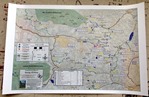
I created the first RoutePlanner map for the 2013 FJ Summit in Ouray, Colorado. It covers most of the trails in the Telluride, Silverton, Lake City, and Ouray areas, and all the trails are featured in the FunTeks book “Guide to Colorado Backroads & 4WD Trails”. This map is feature rich, double sided, and is printed on heavy waterproof paper. It’s also available as a GPS enabled PDF map through the Avenza PDF Map Store for both iOS and Android devices.
See this map & learn about others we’re working on over at Way2Tread.